Magdalen Road at night

Magdalen Road at night
December 2010

Thursday, 18 May 2023

A third walk along the walls (May 2023)


This time we’re doing a circular walk looking at the neighbourhood walls, around the grounds of four former villas from past centuries.  The walk proper starts at the junction of Wonford Road and St Leonard’s Road, just a short way from the village shops.  St Leonard’s Road was once an approach to Mount Radford House and the cedar tree is a reminder of the trees that lined the mansion’s drive. 


Walking towards Topsham Road from the junction, there are Victorian houses on both sides, with the Woodhayes Care Home formed from three of them.  The abandoned bus shelter is a relic from the 20th century.  After the fourth house on the left there is a footpath leading to West and East Grove Roads.  The path marks the boundary of The Grove whose estate was developed for the terraced houses round about 1900.  The Grove had a lodge (where house 39 stands) and an entrance drive (houses 41 and 43 are built over it).  The wall on the left is typical of the many Heavitree stone (Breccia) walls with added stones from other quarries --- until you find something quite different.  The builders incorporated some large hard stones that have been polished in river or sea.  Why and where from?  


Back on the main road, the Victorian houses continue on the right-hand side of the road.  As in the road nearer the village, some of the walls have granite toppings and the remains of railings.  One property has the stumps of very thick railings --- the salvage crew in WW2 chose not to cut through them.   


The bricks here include many with a white glaze, adding visually to both sides of the road.  There’s plenty of Breccia to be seen here, including on the boundary wall of the houses in St Leonard’s Place.  There’s volcanic trap there; did someone salvage that from Exeter’s city walls?   


And don’t miss the street sign, with its “pointing finger”.   


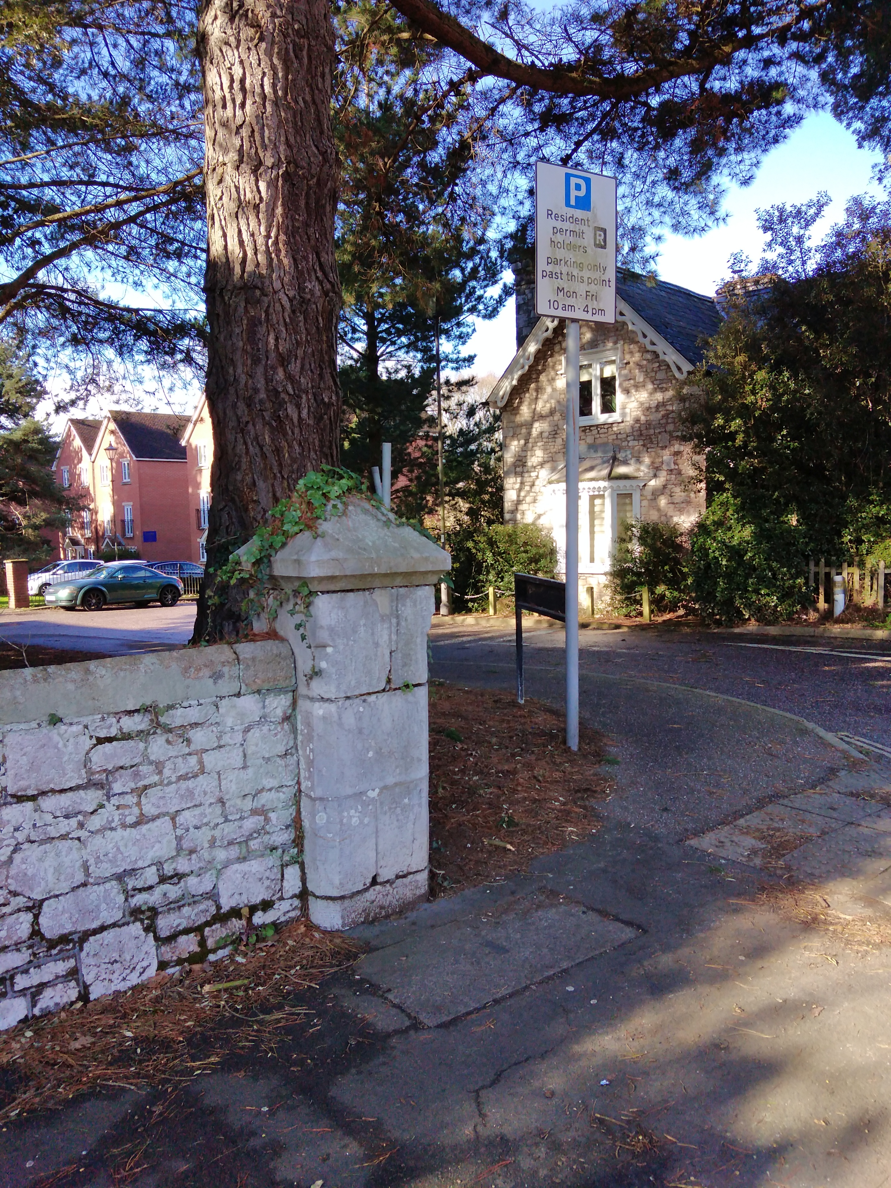
St Leonard’s Lawn straight ahead was part of the front lawn of Mount Radford House (Barnardo Road is on the site of the house).  The road always curved around the lawn, though one old map shows a public footpath across it.

Psychologists tell us that it is hard to notice when something is not to be seen; so what is missing?  From here on, Dartmoor granite is little used.  The approach to Claremont (the second of the villas on this walk) has a gatehouse and walls of stone from beyond the city; grandeur on the cheap, costing less than granite, but definitely more upper-crust than brick or Breccia. 

The school is built on the site of Parkers Well House, whose grounds stretched from here to Matford Lane.  Some of its estate walls are intact, others have been replaced over the years.  The walls were built before the widespread availability of granite in the city.  After the school gates there is a cob wall on a foundation of Breccia; stand here on a sunny afternoon in the early summer and you are likely to see masonry bees entering nests in the cob --- and at any time you can find the small holes they use.  An old saying is that a cob wall has “its hat dry and its feet wet”; the hat is made of tiles, the feet are on porous stone – however the wall lacks protection from the weather and is slowly eroding.  (But school budgets do not include a heading for “repair of cob walls”!)


Round the corner is a gateway for Parkers Well House, now a little overgrown; the family sought to impress passers-by with this brick entrance; pause to look at the fancy brickwork on the curved wings of the gateway.   


Because of the slope of Topsham Road, the next section of boundary wall is much higher, and the brick walls are on a base of stone.  Hidden at the top are iron railings; they possibly survived the war, but may be an addition to protect schoolchildren.  The foundation wall here has a few pieces of water-washed stone; they are generally much smaller than the blocks seen earlier and have been used to fill in cracks where the quarried pieces were uneven.  (In other parts of St Leonard’s, clay roof tiles have the same purpose.)  


Turn up Matford Lane (averting your gaze from the modern development opposite); opposite you are the impressive granite gateposts of Coaver.  Just reflect on the effort to shape them, transport them and erect them with few mechanical aids!  The walls around Parker’s Well are stone, and the well itself has a pleasant stone arch.   


On the left are the sandstone walls of Parkers Well House, now playing fields for the school.  Several years ago, part of the wall collapsed, blocking the road.  The repaired wall can be recognised with its modern mortar.  Further up, a microclimate on the wall means it is partly covered by a large patch of moss.


It's worth a diversion to the right, into the grounds of County Hall, and a short way along, on the left is a high stone wall; this was the boundary wall of the grounds of Coaver, and there are small signs in the structure that this was once the wall of a glasshouse, facing south to take advantage of the sun.  (Edward Parfitt, who was Coaver’s gardener in the 1850s, was a nationally known botanist, familiar with the flora of tropical Africa, which may have led to the construction of a building for delicate plants.) 

Back on Matford Lane, Wayland Avenue has a dog-leg route around the terrace of army officers’ houses.  The small side wall is stone topped with brick; just round the corner is a cob wall, with a rough stone base, exposed to the elements to keep it damp, and a tiled top.  The limestone wall on Matford Lane belongs to the former rectory of the parish church, and then just round the corner is a small reminder of the fourth villa, the lodge of Fontmell.

We are back in Wonford Road, and refreshments await us in the village, a quarter of a mile away. 


Tuesday, 14 March 2023

A second walk along the walls (2023)

In the first of these walks, we went as far as Matford Lane along Wonford Road.  In the slightly warmer months of spring, we’ll go eastwards along Wonford Road to Barrack Road.  As I pointed out in the first article, until the 20th century, traffic flowed from Matford Lane into the east end of Wonford Road.  After Lyndhurst Road, the walls on the left illustrate three different approaches to using Heavitree Breccia (the sandy stone); the walls were the boundaries of three 19th century properties.  First a very well made wall of regular blocks from the local quarries --- regular meaning rectangular, even if not all the same size.  Past the gate, to the second property wall, and there are several very small “filler” blocks.  But the sad aspect of this wall is that the mortar has been repaired with a very hard concrete, which has led to damaged stones; water has been trapped behind the tough material, eroding the sandy material.  (On the opposite side of the road is the coach house of Lahill; the house was lost in the Second World War, and there are a few fragments of the stones of its boundary walls.)  The third part of the wall on the left of Wonford Road used lower quality stones and this material has been shaped by rainwater and the splashes from traffic in rainstorms.  The result is an irregular surface. 

Water splashes have created holes in the wall ---sometimes used for birds' nests

It is worth walking a short way along the two side roads here.  To the left, Victoria Park Road runs between two 19th century properties; on the left is Magdalen Court School, built around “Fairhill”.  Parts of its walls survive, most notably at the north end of the property, where there are stones from a rougher wall.  Turn round here, and look past the cricket pavilion to see the raised glass canopy of the structure In the grounds of Larkby --- a Victorian racquets court, a grade II listed building.  Once back at the junction, take a look down Matford Avenue.  On the left, there is an Edwardian brick wall, which provides a uniform front to the properties.  Opposite, the two blocks of 1930s semi-detached houses have a stone wall; it has been built with much smaller stones than those on the main road and show a range of types of stone, mainly Breccia and Pocombe stone, but with occasional pieces of trap and granite…probably what the builder had in his stock.  The smaller stones in these walls could be laid by one person; that’s not possible with the larger blocks in the older walls.

Larkby’s wall facing Wonford Road uses good quality Breccia, but even this may be eroded as can be seen at the corner by the postbox (installed in the reign of Edward 7th, reflecting the business from the increased number of local houses) and in patches further along.  Mardon House is built on the site of Matford Lodge, the lodge building for the eastern half of today’s Larkby Centre and its wall continues the Breccia --- but this section shows less attention to maintenance.  Further along, on the right is Old Matford with a 400-year old cob wall topped with tiles and protected against the weather with porous rendering.  The opposite side of road sees a sudden transition of material and quality.   

Irregular filling on the left

 Why?  Have a look at the kerbstones of the pavement; they are dropped, because this was a field entrance until after the Second World War, leading into the allotments which existed before the development of the Nuffield Hospital.  The walls look as if they have been formed from a heap of odd blocks --- put together with care, but not for aesthetics!  A little further, a second dropped kerb marks another former gateway, but the filling here is significantly better.   

Neat filling on the left

The stone wall comes to an end at the small stream just before the hospital entrance.  From the end of the Larkby wall to here, the original walls are well-built, but use a wider range of quarried stones than those used for the fine houses earlier.  Appearance was not so important for small-holders.

Entrance to Gras Lawn

Beyond the stream the old walls have been lost to development, but on the opposite side of the road are the limestone walls and lodge of Gras Lawn, the former home of members of the Veitch family.  It was a modest home, and the modesty extended to the small gateposts.  Barrack Road’s walls are a mixture from several eras and have been much altered over the 20th century.

Next issue we’ll explore some different walls.

David Smith  (http://lookatstls.blogspot.com/)

Keywords: St Leonards, Exeter, history, geography, beauty


Monday, 16 January 2023

Walk along the Walls of St Leonard's

Several years ago, I wrote a series of articles for the St Leonard's Neighbourhood News inviting you to look around at some of the interesting and unusual features of St Leonard’s.  One of those was a brief introduction to the stones of the area.  And that led to a puzzled resident curious about the flint nodules in her garden – imported from a long way away to be decorative!

Come with me on a winter walk to look in more detail at how local stones have contributed to the street scene of the neighbourhood.  It’s easy to recognise five types of stone to be seen when you are walking along our streets and roads, without looking for decorative rocks from outside Devon.  Most obvious is granite, from Dartmoor.  And then there are lots of examples of Heavitree sandstone (Breccia) from the quarries of the Broadfields estate (which is why there is Quarry Lane there!).  Also quite common are examples of Pocombe stone, from the ridge of the hills above St Thomas, particularly from the site of park homes at the top of Dunsford Hill; you can spot this material as it is a grey with a hint of purple, streaked with white.  Volcanic trap, a very hard dark stone, much used in the walls of the city, is found in a few places, and so are blocks of limestone, some quarried from the quarries at Beer. 

Walk with me along St Leonard’s Road, heading south from the traffic lights.  Here are the houses of affluent Victorians, with gardens fronted by walls topped with granite.  Many of the granite blocks carry the marks of former iron railings, cut away to supply metal during World War 2.  There are some granite gateposts as well.   


There were stonemasons working around Exeter, some on the Quay, in the 19th and early 20th centuries, who supplied the Dartmoor granite.  It had travelled by rail, (or a combination of rail and sea) from the moor, much of it shaped there. Walkers on the moor today can find blocks which are, for some reason, shaped but unfinished.  The stones had to be transported from the stonemasons’ yards to St Leonard’s by horse-drawn cart and then manhandled into place.  As a result, granite was an expensive material, appropriate for these houses.. 

Look up into Premier Place, where the wall on the right (25 St Leonard’s Road) is a rough wall of assorted stone, with a lot of nice Pocombe pieces.  The mortar between the stones shows a variety of styles; masons have their own styles for wall-building and repairing.  At the far end of the property, there’s some 19th century Heavitree breccia.  Beyond this there has been much rebuilding since the 1940s


Turn into Wonford Road, and on the left is a small low wall built of scrap stones, collected from the ruined walls after the 1942 bombing. Immediately afterwards, in the brick wall, there is a post-box from the reign of George VI, replacing one lost in the same destruction.  Opposite, at the junction with Park Place, there is a stone placed to force wagon wheels away from the wall.   


Old pieces of Heavitree stone make a low wall on the left, one of the few reminders of the older walls of this section of the road.  Before Lyndhurst Road, there is one older wall on the left, with modern brick pillars at the gates.  It’s the first example of a type of wall that is common in the city, built very carefully with an assortment of stones of many shapes and sizes.  Quarried stone, apart from granite, was cheap, and Victorian masons would have used whatever came to hand when constructing walls for front gardens.

The junction of Wonford Road with Matford Lane and Lyndhurst Road marks the start of a transition from urban to rural ---at least as far as walls go.  Until the mid 20th century, Matford Lane merged on a curve into Wonford Road as the through route.  You can trace the former route in the bushes on the corner.

In the next issue we’ll explore the walls in Wonford Road beyond here.

David Smith 

Keywords: St Leonards, Exeter, history, geography, beauty