Magdalen Road at night

Magdalen Road at night
December 2010
Showing posts with label History. Show all posts

Thursday, 24 August 2023

When was your House Built in St Leonard's, Exeter?


If you visit a stately home, the guidebook will probably tell you a little bit about the history of its construction.  However, it may not give you an actual date, just enough to suggest a decade or longer.  What about local houses here in St Leonard’s --- when were they built?  For a few in the neighbourhood, there may be records to show when the first residents moved in to a newly completed building. 

However, earlier this year, after writing in the Neighbourhood News about the stones in our local walls, a local resident contacted me.  Could I help him find when his house was built?  Such a request seemed a little unusual; however, I expressed a willingness to co-operate and after a little research and (I admit, some slight guesswork) we assigned a reasonable date, plus or minus 5 years.  Other information had been lost over nearly two centuries.  Maps didn’t help – nobody was producing updated Exeter street maps every few years!  So what is known about houses in St Leonards’s round about the time that Queen Victoria came to the throne?

The suburb of Exeter saw a lot of houses being built in the first half of the nineteenth century (mainly 1820 onwards).  The late Professor Hoskins, living locally in his retirement, an expert on the history of Exeter and Devon, claimed that some of our houses were built for retired naval officers who were unwilling to retire to fashionable Torquay because of the risk of a French attack on the bay.  (The government built the Palmerston Forts around Plymouth in response to such a threat, and a sub-plot in Jules Verne’s French novel “Twenty Thousand Leagues under the Sea” is about attacking British naval vessels.)  That wasn’t the only reason for Exeter expanding towards Heavitree at that time; wealthy local people wanted to escape the overcrowded city, yet be quite close by.  So our neighbourhood grew and many houses were being built in the years up to 1850.  The house which sparked the investigation was one of the earlier ones. 

According to Professor Hoskins, and another guide to the buildings in Exeter, the opening of substantial brickworks in Polsloe in the 1820s meant that houses in the city were being built with brick from then on.  The grand terraces of Southernhay had been built with brick at the end of the eighteenth century, and it was assumed in the literature that this was a signal for the end of using stone for new buildings.  However, when I spoke to friends living in 19th century houses, they told me that their houses were stone-built, and covered with stucco (rendering).  One of the houses that I enquired about had stone walls for the lower storeys, and brick ones for the top.  All this suggests that the tradition of building with stone didn’t stop with the widespread availability of bricks; stone was being widely used as a building material for another generation --- for the masons building houses, change did not happen overnight, despite the suggestions in the guidebooks.  Unfortunately, the housebuilders didn’t record how and why they had used particular materials. 

We may never know when the first brick-built houses in St Leonard’s were completed, but If you live in a 19th century house in the neighbourhood, and know when it was built and what is under the render, please contact me via the editor. 

David Smith


Tuesday, 4 July 2023

A look at the history of Matford Field, Exeter


 At the east of St Leonard's is an area that was once referred to as Matford Field.  It now consists of the land belonging to the houses in Matford Avenue, Leighdene Close, Matford Road, the flats on the east of Matford Lane and the houses in Wonford Road which abut on this.  This is an attempt to describe the history and development of the area, with the aid of maps and pictures.


The history of St Leonard's by Diamond was published in 1873.  The book included a map showing the church parish 100 years earlier.  Madford Lane curves round to become Wonford Road and leads to Great Madford House (now Old Matford).  Oddly, Bellair is not shown.  The area of Matford Field is blank.

Diamond's second map shows several changes in 100 years.

 
It now shows Bellair and Coaver to the south, the Veitch family home near Barrack Road, and many more houses along Lyndhurst Road, Wonford Road, Victoria Park Road.  There is still no development on Matford Field, as can be seen in the earliest large-scale OS map that I have found online.  In this, as in some other pictures, I have shown the map alongside the image from Google Earth


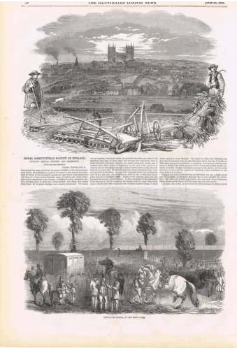
This shows a field division and I have found the two fields with names Matford Great Field and Matford Field.  These two fields were used for the July 1850, the Royal Agricultural Society of Great Britain annual show, which I have described earlier
http://lookatstls.blogspot.com/search/label/Agricultural%20Show

The two fields were covered with wooden sheds for animals and the latest developments in agricultural equipment.  Afterwards there was an auction of fence materials and the wooden sheds --- recycling is not a modern idea, and possibly, the scrap materials from this show were handled in a better way than after some 21st century events where the priority is to get rid of things!


The next reference to the area comes with it being used for rugby, by Exeter's team, at the end of the 1880's.  It appears that there were no facilities for changing and teams changed at a hotel in South Street!

In 1892, an auction was advertised, by which time the road layout had been planned.  Here is the cover of the auction and the accompanying map.


However, at very short notice, the sale was cancelled.  As can be seen from the map, there were now two houses on Matford Field, either side of Matford Road, at the junction with Wonford Road.

These had not appeared on another Victorian OS map, from about 1874, but the Great Field is now shown as an orchard, and the area to the east (Deepdene Close now) is Nursery and the grounds of Old Matford.


At some time after the cancelled sale, four houses were built on the east of Matford Avenue, on the boundary of what became Deepdene Close.  I have found a request for a servant in one of the houses dated from 1913.  Three of those houses stand today.  The fourth was called Deepdene, and the houses of Leighdene Close are built on the large garden of this house.  (I will refer to it as Deepdene House, to prevent confusion with the present private road, Deepdene Close. 


The four houses appear in the map from 1905 along with the coach house on Wonford Road, and Oakdene on the corner of Matford Road and Matford Avenue.  Two plots have been marked out on the east side of Matford Road

More houses were built along Wonford Road, Matford Road and Matford Avenue between the wars.  The map below is dated 1932 and shows the outline of the houses numbers 25,27,29 and 31 in Matford Avenue.  The same two plots are marked in Matford Road, but are not developed.  But The Gables in Matford Road is there.  Deepdene's garden has grown, expanding towards the east and south with formal paths and (possibly) a glasshouse.  There houses and bungalows on the western arm of Matford Avenue.


The map below shows the area in about 1935.  Copies of this map were used (overprinted in German) by the bombers in Exeter's Blitz
 

There are some odd aspects to the housing in this map.  The former Lord Mamhead Homes has a strange garden shape using several plots from the 1892 sale map.  Its neighbour to the south does not fit into any of those plots.  A very strange curved boundary is shown for the original house at the north end of Matford Avenue, fronting Wonford Road.  The large garden of Deepdene appears divided internally, with a strange deviation from the 1892 plots to accommodate a house in what is now Deepdene Park.  The Matford Lane end of Matford Avenue is shown as parkland adjacent to Coaver.  The southern arm of Matford Avenue has been developed.  

And there is a tennis court in the angle of Matford Avenue.  At some stage, the Vicars Choral of Exeter Cathedral (disbanded in the early 1930s) had owned much of old Matford Field as a recreational area, and their financial records show that local house-owners had to pay compensation for "loss of amenity" to this organisation.  (That odd charge remains in the title deeds of several houses.)   Watch out below for the tennis court!

During the blitz, some bombs fell in the area, and the records for May 1942 show a death in Matford Lane, but no mention of bombs in the area, although this is when --- supposedly --- Deepdene House was destroyed by a firebomb and other houses were damaged.  

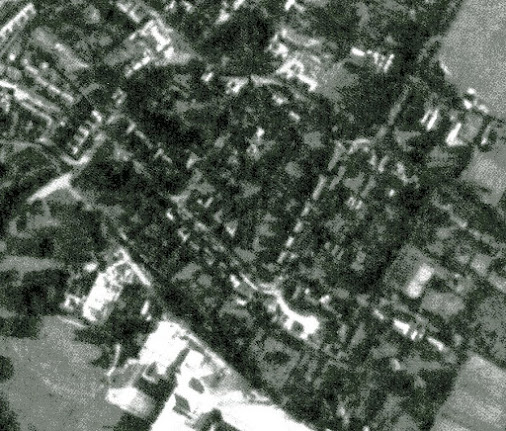
After the war, the RAF took aerial photographs of much of Britain.  Here are some:

That's dated 30th September 1945 and shows the tennis court and a formal garden to the east of the ruins of Deepdene House, along with new houses in Deepdene Close. 

 
8th July 1946 

10th June 1947 showing some areas which look like allotments at the west end of Matford Avenue

20th February 1957 --- the tennis court has gone, ready for new houses; Deepdene House gardens are being cleared.

26th July 1963; rather indistinct but the outline of Leighdene Close is clear; work is in progress on building County Hall.

And now:


Friday, 16 March 2018

Looking for old advertisements in Exeter


This month, the challenge is to look up for faded advertisements, across the city.  

From the start of the 19th century, businesses used the walls of houses and shops as a space to display publicity.  Paint could be used more easily, and more durably, than paper posters.  Sign-writers extended their skills from lettering on shop fronts to decorating larger areas.  The practice continued until the middle of the last century.  Changes of ownership, and the trades concerned led to some of these large advertisements being overpainted.  Since then, the signs have faded, and in many cases, have been erased from their walls.  

Interest in what remains has led to numerous books about “ghost signs” in the UK and other countries.  Spotters of such relics have recorded many ghost signs in urban New York and smaller US cities, and there are books about the ghost signs of Bath and London, plus websites for other localities.  

So what about Exeter?  There was a painted sign in the village, many decades ago for the dairy – now the fishmonger.  But it has been lost, like many others.  But some survive beyond the neighbourhood.  Perhaps the best in Exeter is on a wall by Cowley Bridge Road.  It advertises Redline petrol, a brand which existed in the 1930s and 1940s, including a picture of the top of an old petrol pump.  This is the only surviving advert for the company in the UK, though, bizarrely, one of the shops in Princesshay has used a fuel can for the Redline brand in its “retro” styling.  

Nearer to us, there is an advert for the Royal Society for the Blind in Palace Gate – like many, it is on a wall that faces away from the main road, so you can see it when walking towards South Street from the cathedral.  A partly illegible sign for a business in Gandy Street can be found in Baker Street, just off Magdalen Road as it approached the Gordon Lamp in Heavitree.  Further east through Heavitree, a ghost sign advertises “Chemist” in Victor Street.  

My (very short) list of Exeter’s ghost signs also records those for the Polsloe Dairy in Jubilee Road, Pearks Baking Powder in Cecil Road, St Thomas, Holwill’s Dairy in St David’s Hill, and the Lamacraft brewery overlooking St Sidwell’s School.  A faint advertisement for a Victorian cigar Importer is on a wall in Fore Street.

These relics of old Exeter businesses are rare survivals – look out for them in our city, and keep your eyes skinned for similar survivors if you are travelling this Easter.  Do let me know of any others in the city.
 
Keywords: St Leonards, Exeter, history, geography, beauty, ghost signs